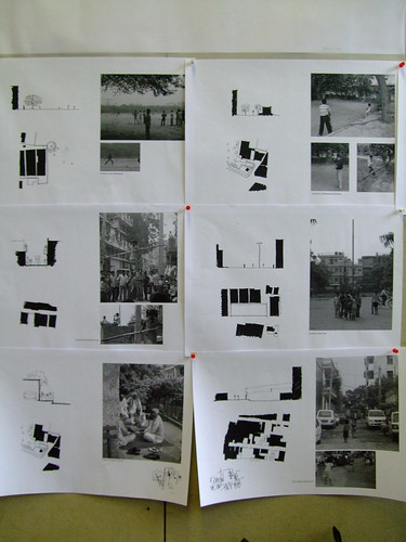
 Architecture students I met at London Metropolitan University are working with two informal settlements in India, Panchsheel Vihar and Chirag Delhi, which they visited at the end of 2008. These settlements are west and east of the Madapuri Stream, and between two of the seven ancient cities of Delhi. The latter 500m x 500m village has a population of 80 000, only three storeys (a density of 3200 persons per hectare). The students' collection of site information, surveys, analysis and photographs of these informal settlements forms the background for proposing improvements to public spaces.
Diverse precedent studies included one student reviewing Chandigarh*, Archigram and markets in Petaling Jaya. Her project connects many rooftops, with complex effect on private and public space thresholds. Another identified genial occupations of the street, but did not have a clear proposition for any improvement to the neighbourhood. I suggested projects might reference development of communities through local education organisations like SEWA, or like Mongolia's MWFA.
In an age of studios where images of even Panchseel Vihar and Chirag Delhi are accessible via google earth and websites, a student collage of an anonymous map profile caught my eye. In a clipping of an ancient map called "Terra Incognita", I recognised the coast of Western Australia. Like one by Robert de Vaugondy (Didier) 1756, only the west coast was distinct, which suggests it was from the 17th century, when Hondius was still drawing connections between Terra Australis Incognita and the Orient. As students grapple with cross sections of villages and of social strata, Terra Incognita takes on others meanings in 2009.
* Chandigarh conference (see also flickr photos)


No comments:
Post a Comment